June 2018 - Grant Awarded
The Gulf Coast Research Laboratory at the University of Southern Mississippi received a grant from the Gulf States Marine Fisheries Commission (GSMFC) for a project: “Permitting a finfish aquaculture operation in the Gulf of Mexico.” Partners include New Hampshire Sea Grant at the University of New Hampshire and the Mississippi-Alabama Sea Grant Legal Program (MASGLP) at the University of Mississippi School of Law.
The Project Team requested funds to conduct the preliminary studies necessary to submit permit applications to the Environmental Protection Agency (EPA) and the U.S. Army Corps of Engineers (Corps) for a finfish mariculture operation in the Gulf of Mexico. Under the terms of the grant, the Project Team would seek an industry partner which would take over permitting and operations once the permit applications were filed. The grant also funds outreach and education regarding finfish mariculture and the permit application process.
August 2018 - Commercial Producer Identified
Manna Fish Farms, Inc. signed a Memorandum of Agreement to be the commercial operator for the finfish operation. Manna Fish Farms, Inc. is a Suffolk County, New York business started in 2013 by Donna Lanzetta, President. Its goal is to develop finfish aquaculture in U.S. federal waters.
September 2018 - Permit Rules Changed
At the time the grant was issued, permitting for mariculture in federal waters of the Gulf of Mexico was conducted under regulations issued by the National Marine Fisheries Service (NMFS) of the U.S Department of Commerce National Oceanic and Atmospheric Administration (NOAA). Under the NMFS regulations, compliant finfish mariculture operations would receive a 10 year permit. However, a court nullified those regulations.
Even if NOAA had remained a permitting agency, mariculture operations would still require permits from the EPA and the Corps. The ruling changed only the permitting role of NOAA.
October-November 2018 - Site Pre-screening Conducted
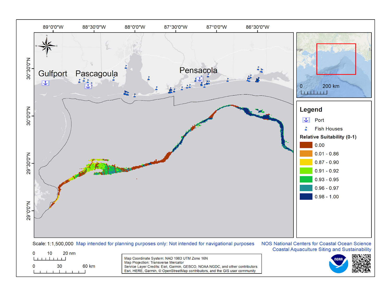
In its grant proposal, the Project Team proposed locating the aquaculture operation in the Northern Gulf at a location somewhere between the Mississippi/Louisiana border and the Florida bend. The NOAA Coastal Aquaculture Siting and Sustainability Program provided general information to assist with finding a site suitable for a 120-acre farm, the projected size of the operation. The depth had to be 50 - 55 meters with a current speed greater than 0.15 meters per second to allow adequate water circulation around the fish cages. Additionally, the site needed to be in federal waters of the Northern Gulf (at least 9 miles from the coast of Florida, and at least 3 miles from the coasts of Alabama or Mississippi). It needed to be near a port with fish processing, and ideally near an onshore hatchery. An initial survey was conducted by the NOAA National Ocean Service (NOS) that considered a range of activities in federal waters such as: military zones, gas/oil platform and pipelines, artificial reefs, navigation fairways, ocean Dredged Material Disposal Sites, shipwrecks, National Marine Sanctuaries, Essential Fish Habitat under the Magnuson-Stevens Fishery Conservation and Management Act, critical habitat under the Endangered Species Act, and fishing sectors. The preferred site selected by the Project Team is 20 nautical miles from Pensacola, Florida.
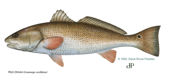
2018 - Production Species Identified
The species chosen to be farmed is red drum (Sciaenops ocellatus). Red drum is found along the Atlantic Seaboard and the Gulf of Mexico. It is also called redfish, channel bass, spottail bass, or puppy drum. Red drum and the striped bass were classified as protected game fish in 2007 under a Presidential Executive Order. The Order prohibits commercial harvest of the fish, but allows “the production, possession, or sale of striped bass or red drum fish that have been produced by aquaculture.”
February 2019 – Department of Defense Notice Received
At the request of NOS, the Military Aviation and Installation Assurance Siting Clearinghouse within the Department of Defense coordinated an informal review of the project. The Department of Defense notified the project team that the proposed site would not interfere with defense-related activities.
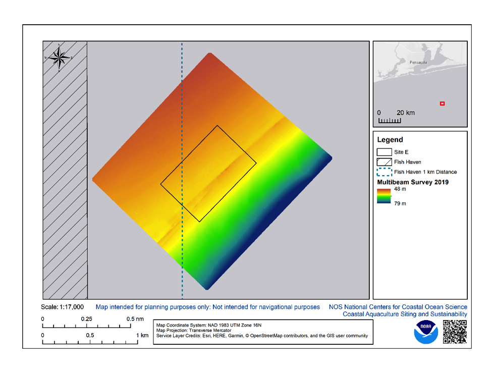
April - May 2019 – Initial Bathymetric Survey Conducted
Multibeam echosounder, sidescan sonar, magnetometer and sub-bottom profiler data were collected and assessed for the initial bathymetric survey area of 700 acres. The data assessment revealed a generally smooth seafloor topography which slopes to the southeast. A small ridge runs across a portion of the area in a northeast/southwest direction and appears to contain some areas of hard substrate that could support biological communities, such as sponges or coral.
April 2019 – Endangered Species Listed
In April 2019 NOAA announced the Bryde’s whale was an endangered species under the ESA. While the Bryde’s whale was proposed for listing in 2016, and was always protected under the Marine Mammal Protection Act, the 2019 announcement altered the range of its protected habitat slightly. The project team shifted the preferred site for the aquaculture operations to minimize interactions with the Bryde’s whale.
June 2019 – Gulf of Mexico Fishery Management Council & Stakeholder Workshop Held
The Project Team presented a summary of the Manna Fish Farms’ mariculture project to the Habitat Protection and Restoration Committee of the Gulf of Mexico Fishing Management Council at its meeting on June 3, 2019. The presentation was followed by a workshop for stakeholders.
August – October 2019 – Currents Assessed
Beginning in August, an acoustic doppler profiler was used to assess currents in the proposed site. The 90-day time period for the deployment was chosen as when currents are the strongest in the Northern Gulf. Data on currents are used by the EPA to model effluent discharge from the cages and by the team to site the cages and select mooring and monitoring equipment.
October 2019 – Phase II of the Project Started
January - February 2020 – Second Bathymetric Survey Prepared
The 2019 bathymetric survey revealed potential hard bottom at the proposed site. Bathymetric surveys cannot identity whether or what biota is present. For this reason, EPA indicated that the proposed site must be 1,000 m from any hard bottom. A second bathymetric survey of an adjusted project site to avoid hard bottom was planned for early 2020. The second survey was postponed due to weather and then due to COVID-19 out of concern for the boat’s crew and surveyors.
2020 - Hatchery identified
Fish must be brought to the finfish cages from onshore hatcheries once they are big enough to be held in the offshore cages. The so-called fingerlings will be raised on shore, offspring of stock harvested from the area of the potential site. The hatchery is located at the University of Southern Mississippi.
December 2020 – Second Bathymetric Survey Conducted
The second bathymetric survey of an additional 1,400 acres was conducted.
January to May 2021 - Baseline Environmental Survey Prepared
An independent contractor prepared a Baseline Environmental Survey for the project. The survey acquired baseline environmental hydrographic and geophysical data to support the project by using a multibeam sonar and a towed array consisting of a combined side scan sonar, subbottom profiler, and magnetometer. An archeologist assessed whether cultural resources may be related to the site, and determined that there were no anthropogenic objects or cultural resources within the surveyed area. Drafts were circulated among the Project Team and federal permitting agencies.
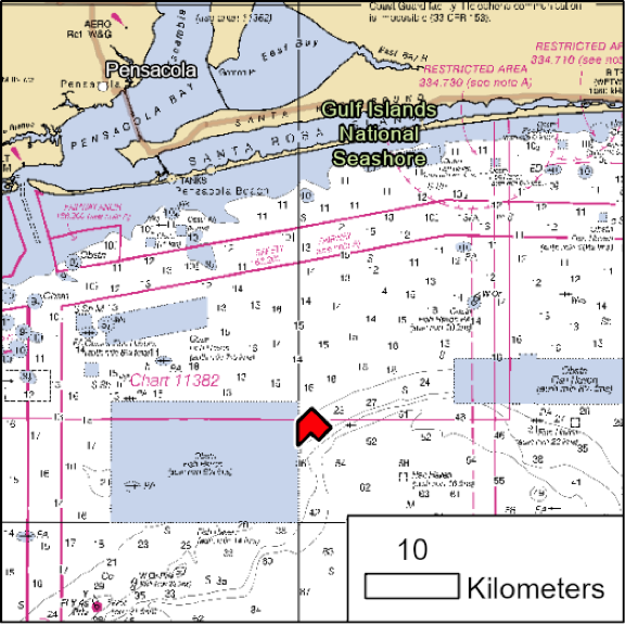 Figure 1 from the Baseline Survey Report:
Overview map with survey area indicated. Background is NOAA chart 11360 with depths shown in fathoms relative to mean low water.
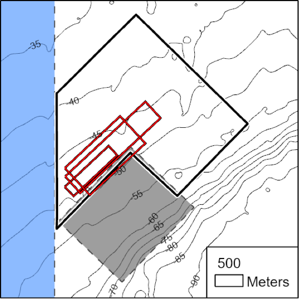 Figure 2 (taken from Baseline Survey Report):
Detail map with survey area outlined in black. Proposed aquaculture sites are outlined in red. The previous surveyed site to the south is shaded gray. The fish management site to the west is shaded blue. Depth contours derived from regional bathymetry are in meters relative to mean lower low water.
March 2021 – Brood Stock Fish Collected
It will take approximately one year once the fish are spawned from the regionally-sourced brood stock to grow large enough to be brought to the cages.
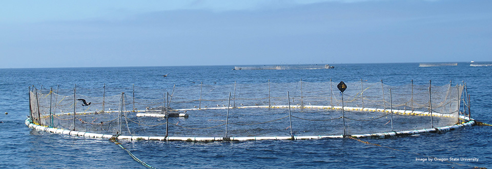
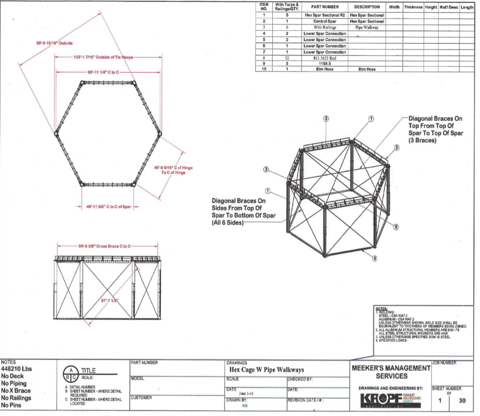
May 2021 - Cage Types and Layout Selected
The Manna Fish Farms Offshore Aquaculture Site in the Gulf of Mexico will have 12 cages when it reaches its maximum capacity, which is a reduction from the initial planned maximum of 18 cages. The cages will not be deployed all at once. At full deployment, the cages will be in three rows, using a remotely operated feed barge to feed the stock. The hexagonal cages are known as StormSafe® Submergible Net Pens. Each cage is 15 m high by 30 m wide and capable of being submerged 15 m during hurricanes and storms. The cages are supported by six surface buoys with drag embankment anchors at each corner. The outer perimeter of the facility will be more than 500 feet from the boundary of the Escambia County artificial reef field, and 1,000 m from any hard bottom.
June 21, 2021 – Presentation Made to Gulf of Mexico Fishery Management Council
April 4, 2022 - Permit Application Filed with the U.S. Environmental Protection Agency
EPA will issue a permit under the Clean Water Act to allow discharges into the waters of the United States from the mariculture operation. This permit is known as a National Pollutant Discharge Elimination System permit, or NPDES. As part of the permitting process, EPA requires submission by the applicant of Best Management Practices for material storage, maintenance, recordkeeping, training, feed management, waste disposal, transport and harvest, and carcass removal.
May 5, 2022 - EPA Deemed the Permit Application Complete
EPA:
The U.S. Army Corps of Engineers (Corps) issues a permit related to its authority to regulate navigable waters under the Rivers and Harbors Act. This is known as a Section 10 permit. The finfish mariculture cages must be anchored to the bottom of the Gulf of Mexico and the Corps must ensure that the system does not interfere with navigation. The Corps issued a Nationwide Permit for finfish mariculture in 2021 to streamline the permitting process.
U.S. Army Corps of Engineers:
NMFS is still involved in mariculture, even though it does not issue a permit. Pursuant to a Presidential Executive Order, NMFS coordinates environmental reviews under the National Environmental Policy Act for aquaculture operations. Additionally, NMFS must be consulted where a project could impact species protected under the Endangered Species Act, and if a project could harm a marine mammal incidentally, such as by interrupting its feeding, for example, the project must get permission from NMFS for the incidental take under the Marine Mammal Protection Act.
NMFS:
NEPA:
The State of Florida must also determine that the project is consistent with its coastal management program under the Coastal Zone Management Act.
Have questions or comments about the Mississippi-Alabama Sea Grant Legal Program?
Stay current with the latest news and information from the MASGLP. Subscribe to our newsletter today!
Mississippi-Alabama Sea Grant Legal Program
256 Kinard Hall, Wing E
P.O. Box 1848, University, MS 38677
Phone (662) 915-7775 • Fax (662) 915-5267